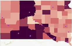
South Dakota Child Care Landscape:
Licensed and Registered Programs
South Dakota's child care mapping helps policymakers to better understand the current supply of child care throughout the state. The maps also show Head Start and Early Head Start programs.
-
Each map can be viewed from a statewide perspective, or you can zoom in to see counties, communities or neighborhoods.
-
A legend is available for each map to describe the type of program shown (licensed centers, licensed group family child care homes, registered family child care homes, etc.).
Mapping Quick Tips:
-
Click on the map to open and view the programs in each type of care category
-
Zoom in to see counties, communities or neighborhoods
-
Click on the symbols/colors in the map to see a pop-up box with program details (program info, census data)
-
On the left panel, view the "legend" to see the color coded symbols for types of child care
-
On the left panel, click on "content" to check or uncheck various categories (some maps are pre-set - for example, licensed centers, but you can still uncheck or check items as you wish)
-
Children in working families have a purple shade (the darker the purple color, the greater the percentage of children in working families).
-
Poverty levels are reflected with various shades of red (the darkest red indicating highest poverty).
-
Map loading time may take a few seconds so be patient!
-
Your view of the interactive maps below can be customized by checking or unchecking the features you would like to see.
Colored backgrounds
The maps are set to U.S. Census Bureau data that shows children in families where all parents are working. Viewers can also choose to see a background layer reflecting children in poverty or a background layer reflecting the percentage of children in homes where Spanish is spoken at home.
Background Explainer: Children in Working Families and Levels of Poverty (the purple and red shading)
PURPLE
Children in Working Families
The darker the shade of purple, the greater the percentage of children in working families. This is referred to as a working families layer.

DARK RED
Children in Poverty
Click below to see licensed group family child care homes in South Dakota.

Data Maps
All SD Child Care Programs
Click below to see all child care programs in South Dakota. It takes a few minutes for all the variables to load. Visitors may want to unclick all the layer options (types of child care) once the map fully loads. To do so, click "content" on the left-hand side to click or unclick variables, and click on each layer you want to add to the map. Zoom in to check out your neighborhood!

Sources: South Dakota Department of Social Services (December 2023), U.S. Census Bureau 2021 American Community Survey, 1 Year Estimates; and U.S. Census Bureau Economic Survey, NS1900 NONEMPAll Sectors: Nonemployer Statistics for the U.S., States, and Selected Geographies: 2019.


